
The Peninsular Plateau
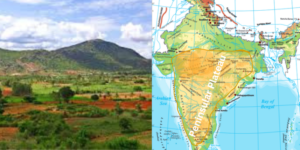
- The Great Peninsular Plateau, located to the south of the Great Northern Plains, is a vast tableland comprising old crystalline, igneous, and metamorphic rocks. It covers approximately 16 lakh square kilometers, nearly half of India’s total area.
- This irregular triangle rises from about 150 meters above the river plains to elevations of 600-900 meters. Surrounding it are the Delhi ridge in the northwest (an extension of the Aravalis), the Rajmahal hills in the east, the Gir range in the west, and the Cardamom hills in the south.
- Additionally, an extension is visible in the northeast, in the form of the Shillong and Karbi-Anglong plateau, separated by the Malda fault.
- One of its notable features is the Deccan Trap, an area of black soil of volcanic origin. Formed when the Indian plate moved over the Reunion hotspot, basalt lava spread to create these igneous rocks, which have since denuded, contributing to the formation of black soil.
- The Peninsular India is characterized by a series of plateau regions such as Hazaribagh, Palamu, Ranchi, Malwa, Coimbatore, and Karnataka, among others. This region is among the oldest and most stable landmasses in India.
- The plateau’s general elevation is higher in the west and decreases towards the east, as evidenced by the river flow patterns.
- Major rivers like the Krishna, Kaveri, and Godavari originate from the Western Ghats and form deltas on the Bay of Bengal side.
- The plateau has undergone significant denudation, resulting in relic mountains and broad, shallow valleys. Physiographic features include tors, block mountains, rift valleys, spurs, bare rocky structures, hummocky hills, and quartzite dykes, providing natural sites for water storage.
- The Peninsular plateau has experienced recurring phases of upliftment and submergence, accompanied by crustal faulting and fractures, leading to spatial variations and diverse relief features.
- The northwestern part of the plateau features a complex relief of ravines and gorges, with notable examples being the ravines of Chambal, Bhind, and Morena. Based on prominent relief features, the plateau can be broadly divided into three groups.
Physiographic Divisions:The Peninsular Plateau
- On the basis of prominent relief features, the peninsular plateau can be divided into three broad groups:
- The Central Highlands
- The Deccan Plateau
- The Northeastern Plateau.
1.The Central Highlands:The Peninsular Plateau
- The Central Highlands are the northern segment of the Peninsular Plateau and are located north of the Narmada River.
- Bounded by the Aravalli Range to the west and the Satpura Range to the south, they have a general elevation of 700-1,000 meters above sea level, sloping towards the north and northeast.
- Key features of the Central Highlands include:
- Marwar Upland: Located to the east of the Aravallis in Rajasthan, it is a rolling plain carved by the Banas River, with an average elevation of 250-500 meters above sea level.
- Madhya Bharat Pathar: Lies to the east of the Marwar Upland and is characterized by its extensive lava flow and black soils.
- Malwa Plateau: Situated in Madhya Pradesh between the Aravalli and Vindhya ranges, the Malwa Plateau is known for its rich black soil.
- Bundelkhand Plateau: Located along the borders of Uttar Pradesh and Madhya Pradesh, this plateau is characterized by its semi-arid climate, undulating terrain, and unsuitability for cultivation due to intensive erosion.
- Baghelkhand Plateau: Lies to the east of the Maikal Range.
- Chhotanagpur Plateau: Located in the northeast part of the Peninsular Plateau, it includes parts of Jharkhand, Chhattisgarh, and West Bengal. The plateau consists of a series of step-like sub-plateaus and is known for its mineral wealth.
- Rajmahal Hills: Northeastern projection of the Chhotanagpur Plateau.
- The Central Highlands stretch between the Vindhyachal Range in the south and the Great Northern Plains in the north, with the Aravalli Range forming its western and northwestern
- The region is rich in mineral resources and has undergone metamorphic processes, as evidenced by the presence of rocks such as marble, slate, and gneiss. Several important rivers, including the Yamuna’s tributaries and the Banas River, originate from the Vindhyan and Kaimur
- The extension of the Peninsular Plateau can be observed as far as Jaisalmer in the west, where it is covered by longitudinal sand ridges and crescent-shaped sand dunes called barchans.
2. The Deccan Plateau:The Peninsular Plateau
- The Deccan Plateau, the largest region of the Great Indian Plateau, covers an area of approximately 700,000 square kilometers.
- Its triangular shape extends southward from the Narmada River, with the Western Ghats bordering it to the west, the Eastern Ghats to the east, and the Satpura, Maikal range, and Mahadeo hills to the north.
- The Satpura range consists of scarp plateaus on the southern side, varying in elevation between 600-900 meters.
- These relict mountains have undergone significant erosion, resulting in disjointed ranges. The Deccan Plateau is higher in the west and gently slopes towards the east.
- The Western Ghats, known by various names such as Sahyadri in Maharashtra, Nilgiri hills in Karnataka and Tamil Nadu, and Anaimalai hills and Cardamom hills in Kerala, are block mountains formed by a portion of land sinking into the Arabian Sea.
- Extending parallel to the western coast from the mouth of the Tapi River to Kanyakumari, the Western Ghats have a steeper western slope compared to the gentler eastern slope.
- Major passes such as Thal, Bhor, and Pal Ghats traverse the Western Ghats.
- On the other hand, the Eastern Ghats stretch from the Mahanadi Valley to the Nigiris in the south.
- The Eastern Ghats are characterized by their discontinuous and irregular nature, dissected by rivers like the Mahanadi, Godavari, Krishna, and Kaveri, which drain into the Bay of Bengal.
- To the southeast of the Eastern Ghats, one can find the Shevaroy Hills and the Javadi Hills.
- In terms of elevation, the Western Ghats are relatively higher (900-1600 meters) and more continuous compared to the Eastern Ghats (600 meters).
- The average elevation of the Western Ghats is approximately 1,500 meters, with height increasing from north to south.
- The highest peak of the Peninsular plateau, Anamudi (2,695 meters), is located in the Anaimalai hills of the Western Ghats, followed by Dodabetta (2,637 meters) in the Nilgiri hills.
- The Eastern Ghats boast Mahendragiri (1,501 meters) as their highest peak. The Nilgiri hills serve as the meeting point of the Eastern and Western Ghats.
3. The Northeastern Plateau : The Peninsular Plateau
- The North-Eastern Plateau, an extension of the main Peninsular plateau, is locally known as the Meghalaya and Karbi-Anglong Plateau.
- It is separated from the Chotanagpur Plateau by the Malda fault. Over time, sediment deposition from numerous rivers has filled up this depression.
- The Meghalaya plateau can be further divided into three regions: the Garo Hills, the Khasi Hills, and the Jaintia Hills, named after the tribal groups inhabiting the area.
- A similar extension is also seen in the Karbi Anglong hills of Assam, with Shillong being the highest peak in this plateau.
- Rich in mineral resources such as coal, iron ore, sillimanite, limestone, and uranium, the Meghalaya plateau receives the highest amount of rainfall during the southwest monsoon, resulting in a highly eroded surface.
- The region’s highest point, Shillong (1,961 m), is separated from the peninsular rock base by the Garo-Rajmahal gap.
- The area includes the Garo, Khasi, Jaintia, and Mikir (Rengma) hills, with Cherrapunji displaying a bare rocky surface devoid of any permanent vegetation cover.
Minor Plateaus in Peninsular Plateau:
Marwar Plateau:
- It is the eastern Rajasthan plateau. The Marwar plain lies to the west of Aravalis, while the Marwar plateau is to the east.The typical elevation is 250-500 m above sea level, and the terrain slopes eastward.
- It is composed of Vindhyan period sandstone, shales, and limestones.The Banas River and its tributaries (Berach and Khari rivers) rise in the Aravali Range and flow northwest into the Chambal River. Because of the erosional activity of these rives, the plateau top seems to be a rolling plain.
Bundelkhand Plateau:
- The Yamuna River runs through the north, the Madhya Bharat Pathar runs through the west, the Vindhyan Scarplands go through the east and south-east, and the Malwa Plateau runs through the south.
- It is the ancient dissected (split by several deep valleys) upland of the ‘Bundelkhand gneiss,’ which is made up of granite and gneiss.
- It is divided into five districts in Uttar Pradesh and four districts in Madhya Pradesh.This region has an average height of 300-600 m above sea level and dips down from the Vindhyan Scrap toward the Yamuna River.
- A chain of hillocks (little hills) built of granite and sandstone define the region.The erosion process of the rivers that pass through here has changed it into an undulating (wave-like surface) land that is unsuitable for farming.
- The topography of the region is characterised by senile (typical of or produced by old age).The plateau is traversed by streams such as Betwa, Dhasan, and Ken.
Chotanagpur Plateau:
- The Chotanagpur plateau is the Indian Peninsula’s north-eastern protrusion.Mostly in Jharkhand, northern Chhattisgarh, and West Bengal’s Purulia area.The Son river travels through the plateau and enters the Ganga.
- The plateau’s average elevation is 700 metres above sea level.This plateau is mostly made up of Gondwana rocks.
- Rivers such as the Damodar, Subarnarekha, North Koel, South Koel, and Barkar have formed enormous drainage basins.The Damodar River flows through the centre of this area, forming a rift valley from west to east.
- The Gondwana coal fields, which supply the majority of India’s coal, are located here.The Hazaribagh plateau, located north of the Damodar river, has an average height of 600 metres above mean sea level.
- There are solitary hills on this plateau. Because of large-scale erosion, it seems to be a peneplain.To the south of the Damodar Valley, the Ranchi Plateau rises to around 600 m above mean sea level. Where the city of Ranchi (661 m) is located, the majority of the terrain is rolling.
- Monadnocks (an isolated hill or ridge of erosion-resistant rock rising above a peneplain) interrupt it in spots. Ayers Rock in Australia is an example of a conical hill.
- The Rajmahal Hills, which comprise the northwestern boundary of the Chotanagpur Plateau, are largely formed of basalt and are covered with basaltic lava flows.They go north-south and reach an elevation of 400 m on average (highest mount is 567 m). These hills have been subdivided into plateaus.
Malwa Plateau:
- The Malwa Plateau generally forms a triangle centred on the Vindhya Hills, delimited in the west by the Aravali Range, in the north by Madhya Bharat Pathar, and in the east by Bundelkhand.
- This plateau has two drainage systems, one towards the Arabian Sea (through the Narmada, Tapi, and Mahi) and the other towards the Bay of Bengal (Chambal and Betwa, joining the Yamuna).
- The Chambal and many of its right bank tributaries, including the Kali, Sindh, and Parbati, drain it in the north.It also covers the upper courses of the Sindh, Ken, and Betwa rivers.
- The overall slope is northward [from 600 m in the south to less than 500 m in the north].This is a river-cut plateau with undulating hills. The Chambal ravines delineate the plateau to the north.
Baghelkhand Plateau:
- Baghelkhand is located north of the Maikal Range.On the west, it is composed of limestones and sandstones, whereas on the east, it is composed of granite.
- In the north, it is surrounded by the Son River.The plateau’s middle section serves as a water divide between the Son drainage system to the north and the Mahanadi river system to the south.
- The terrain is uneven, with elevations ranging from 150 to 1,200 metres.The Bhanrer and Kaimur are situated near the trough-axis.The overall horizontality of the strata indicates that no substantial disturbance has occurred in this location.
Meghalaya Plateau:
- Beyond the Rajmahal hills, the peninsular plateau stretches eastward to Meghalaya or the Shillong plateau.This plateau is separated from the main block by the Garo-Rajmahal Gap.
- This chasm was created via down-faulting (normal fault: a block of earth slides downwards). Sediments deposited by the Ganga and Brahmaputa later filled it.Archaean quartzites, shales, and schists make up the plateau.
- The plateau descends down to the north to the Brahmaputra river and south to the Surma and Meghna valleys.Its western border is roughly parallel to the border with Bangladesh.
- The plateau’s western, middle, and eastern sections are known as the Garo Hills (900 m), Khasi-Jaintia Hills (1,500 m), and Mikir Hills, respectively (700 m).
- Shillong (1,961 m) is the plateau’s highest peak.
Telangana Plateau:
- Archaean gneisses make up the Telangana plateau.It has an average elevation of 500-600 metres.The southern section is higher than the northern section.Three river systems, the Godavari, the Krishna, and the Penneru, drain the area.
- The plateau is separated into two sections: the Ghats and the Peneplains (a vast featureless, undulating plain which is the last stage of the deposition process).
Maharashtra Plateau:
- It is located in the northern section of the Deccan Plateau.Much of the land is underlain by basaltic lava rocks, the majority of the Deccan Traps are located in this region.
- Weathering has given the land the appearance of a rolling plain.Horizontal lava sheets have resulted in typical Deccan Trap topography.
- The large and shallow basins of the Godavari, Bhima, and Krishna rivers are flanked by flat-topped steep-sided hills and mountains.The entire region is covered with regur, a black cotton soil.
Deccan Plateau:
- It has a land area of around 500,000 square kilometres.It is triangular in shape and is limited in the north-west by the Satpura and the Vindhya, in the north by the Mahadev and the Maikal, in the west by the Western Ghats, and in the east by the Eastern Ghats.
- It has an average elevation of 600 metres.It reaches 1000 metres in the south but drops to 500 metres in the north.
- The flow of its principal rivers indicates that its overall slope is west to east.Rivers have fragmented this plateau into several smaller plateaus.
Karnataka Plateau:
- The Mysore plateau is another name for the Karnataka Plateau.It is located to the south of the Maharashtra plateau.The terrain seems to be an undulating plateau with an average elevation of 600-900 metres.
- It is heavily crisscrossed by various rivers that flow from the Western Ghats.The hills’ basic tendency is either parallel to or across the Western Ghats.Mullayanagiri, in the Baba Budan Hills of Chikmagalur district, has the highest peak (1913 m).
- The plateau is separated into two sections known as Malnad and Maidan.Malnad is Kannada for “high country.” It is divided among deep valleys with lush trees.
- The Maidan, on the other hand, consists of an undulating plain with modest granite hills.In the south, the plateau tapers between the Western and Eastern Ghats and merges with the Nilgiri hills.