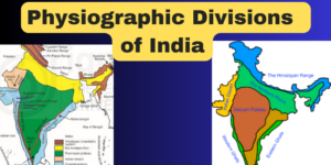
Physiographic Divisions of India
- Physiographic Divisions of India,Northern borders defined by the Himalayan range shared with China, Bhutan, and Nepal.
- Western boundary with Pakistan formed by Western and Karakoram Himalayan peaks, Punjab Plains, Thar Desert, and Rann of Kutch salt marshes.
- Chin Hills and Kachin Hills separate India and Burma in the northeast.
- Eastern border defined by Indo-Gangetic Plain, Khasi and Mizo Hills, and Bangladesh’s eastern border.
- Ganges is India’s longest river, sourced within India.
- Ganges-Brahmaputra system covers northern, central, and eastern
- Deccan Plateau dominates southern India.
- Kangchenjunga, third-highest peak, located in Sikkim.
- Southern region has an equatorial climate, while upper Himalayan highlands are alpine and tundra.
- Indian Plate is part of the Indo-Australian Plate in the north.
- Complex geological structure with rocks from various geologic eras.
- Physiography influenced by structure, process, and stage of development.
- Northern rocky geography includes mountain ranges, valleys, and canyons.
- South characterized by stable table land, dissected plateaus, denuded rocks, and developed scarps.
- North Indian plain lies between the northern and southern regions.
- The following physiographic divisions can be used to categorise India’s physical characteristics.
- The Himalayan Mountains
- The Northern Plains
- The Peninsular Plateau
- The Indian Desert
- The Coastal Plains
- The Islands
The Himalayan Mountains:
- The Himalayas are geologically young and structurally fold mountains.
- They stretch from the Indus to the Brahmaputra, running west to east.
- The Himalayas are the world’s highest and one of the most difficult mountain ranges.
- The Himalayas are made up of three parallel ranges: Himadri (Greater Himalayas), Himachal (Lower Himalayas), and Shiwaliks (Outer Himalaya).
- Himadri (Greater Himalayas) has an average height of 6100 meters and includes some of the highest peaks and passes.
- Nepal is home to Mt. Everest, also known as Sagarmatha, the world’s tallest mountain.
- Himachal (Lower Himalayas) has an average elevation of 3700-4500 meters, with important ranges like Dhauladhar, Pir Panjal, Nag Tibba, and Mussoorie.
- Shiwaliks are of recent origin, with an average elevation of 900-1200
- The Trans Himalayan Zones are located north of the Great Himalayas, near the Tibetan border, including ranges like Karakoram, Ladakh, and Zaskar.
- The folding of the Himalayas has been caused by compressional forces from the north, leading to the formation of three successive arc-like ranges.
- Kober’s geosynclinal theory explains the origin of mountains, suggesting that the Tethys geosyncline occupied the present-day place of the Himalayas.
- The Himalayas are divided into four main divisions: Punjab Himalayas, Kumaon Himalayas, Nepal Himalayas, and Assam Himalayas.
- The Himalayas are the result of the Indian and Eurasian plates colliding, with the Tethys sea squeezed between them, leading to the formation of the geosyncline and subsequent mountain ranges.
- The Main Himalayas or Greater Himalayas and Lesser Himalayas were formed due to the convergence of the plates, along with fault lines like the Main Boundary Fault and the Himalayan Frontal Fault.
- The Shivalik Mountains were formed due to deposition and compression in the foredeep on the foothills of the Greater and Lesser Himalayas.
The Northern Plains:
- Formed by sediments brought down by the Indus, Ganga, and Brahmaputra rivers and their tributaries.
- Known as the Indo-Ganga-Brahmaputra plain.
- Formed after the upliftment of the Himalayas, with sediments accumulating in a shallow trough between the Himalayas and the Deccan plateau.
- Located between the Himalayas and the Peninsular plateau.
- Extends 2400 km from east to west, with a width ranging from 150 km to 300 km.
- Includes states like Punjab, Haryana, Uttar Pradesh, Bihar, West Bengal, and Assam.
- Rich alluvial soil supports the cultivation of major crops like wheat, rice, sugarcane, pulses, oilseeds, and jute.
Division into Zones:
- Divided into several regions based on relief features:
- Bhabar: Narrow belt parallel to the Shivalik foothills, where rivers deposit pebbles and disappear.
- Terai: Wet, swampy, and marshy region south of Bhabar where streams reappear.
- Bhangar: Largest part of the plain, composed of the oldest alluvial soil, locally known as kankar.
- Khadar: Floodplains formed by younger alluvium, highly fertile due to annual renewal of soil.
- Divided into several regions based on relief features:
Regional Division:
- Punjab Plains: Formed by the Indus and its tributaries, including Jhelum, Chenab, Ravi, Beas, and Sutlej.
- Ganga Plain: Extends from Ghaggar to Tista rivers, covering states like Haryana, UP, Delhi, Bihar, Jharkhand, and West Bengal.
- Brahmaputra Plains: Forms the eastern part of the northern plain and lies in Assam.
- Heavy concentration of population, supporting one of the densest populations in the world.
- Cultural and political importance, serving as dominant areas for political, economic, and cultural movements.
- Social and religious significance, with the Ganga being considered a sacred river and the area being the holy land of Hinduism.
- Economic significance, with fertile soil, perennial rivers, and favorable climate supporting agriculture and diverse occupations, including commerce and industry.
The Peninsular Plateau:
- The Indian Peninsular Plateau is a hard ancient mass of igneous and metamorphic rocks that is part of the Gondwanaland tectonic plate, making it the oldest landmass on the planet.
- It is generally triangular in form, with its base parallel to the Ganga Valley and its apex pointing to the country’s southernmost
- The plateau is characterized by vast and shallow valleys, as well as rounded hills. The Central Highlands and the Deccan Plateau are its two major sections.
- The Western Ghats in the west, the Eastern Ghats in the east, and the Satpura, Maikal range, and Mahadeo hills in the north define the Peninsular Plateau.
- Key physiographic characteristics include tors, block mountains, rift valleys, spurs, bare rocky formations, series of hummocky hills, and wall-like quartzite dykes, providing natural water storage sites.
- The Peninsular Plateau has been uplifted and submerged several times, leading to changes in its relief. Its northern section features a complicated terrain with ravines and gorges.
- The Shillong and Karbi-Anglong plateau in the northeast serve as an extension of the Peninsular Plateau.
- Peninsular India includes several patland plateaus, such as the Karnataka plateau, Hazaribagh plateau, Palamu plateau, Ranchi plateau, and Malwa plateau, making it one of India’s oldest and most stable landmasses.
The plateau’s outside boundaries are defined by various ranges, such as the Delhi Ridge, Rajmahal Hills, Gir Range, and Cardamom Hills.
- The Deccan Plateau is separated from the Chota Nagpur Plateau by a fault. The black soil area in the Deccan Plateau is known as the Deccan trap, formed due to volcanic eruptions and suitable for cotton and sugarcane cultivation.
- The Western Ghats run parallel to the western coast for about 1600 km, with an average elevation of 1000 meters. They can be crossed through passes like Pal Ghat, Thal Ghot, and Bhor Ghat.
- The Eastern Ghats are a discontinuous low belt with an elevation of 600 meters, running parallel to the east coast from south of the Mahanadi valley to the Nilgiri hills.
- Important rivers like the Godavari, Bhima, and Krishna flow eastward from the Western Ghats, while the Tapti flows westward. The Mahanadi, Godavari, Krishna, and Kaveri river systems drain the Eastern Ghats.
The Indian Desert:Physiographic Divisions of India
- The Indian desert, also known as the Thar Desert or the Great Indian Desert, is located to the northwest of the Aravali hills.
- It covers Western Rajasthan and extends to the adjacent parts of Pakistan.
- Geological evidence suggests that most of the arid plain was under the sea during the Permo-Carboniferous period and was later uplifted during the Pleistocene age.
- The region was once fertile, as indicated by the presence of dry beds of rivers like the
- The desert area is part of the peninsular plateau region but looks like an aggradational plain on the surface.
- The desert has an arid climate with low vegetation cover. The eastern part is rocky, while the western part is covered by shifting sand dunes.
- Bagar, a semi-desert area west of the Aravallis, has a thin layer of sand and is drained by the Luni river in the south, with the northern section having salt lakes.
- The region has short seasonal streams originating from the Aravallis, supporting agriculture in some patches called Rohi.
- The Luni river, a seasonal stream, originates in the Pushkar valley of the Aravalli Range and flows southwest into the Rann of Kutch.
- There are streams that disappear after flowing for some distance, showcasing inland drainage, and join a lake or playa, like the Sambhar Lake, which has brackish water, the main source of salt.
- The desert features sand dunes, including longitudinal dunes, transverse dunes, and barchans, along with mushroom rocks, shifting dunes (Dhrians), and oases, mostly in its southern part.
The Coastal Plains:Physiographic Divisions of India
Western Coastal Plains:
- Extends between Arabian Sea and Western Ghats, 50 km wide.
- Divided into Kachchh and Kathiawar (Gujarat), Konkan (Maharashtra), Goan (Karnataka), and Malabar (Kerala).
- Example of a submerged coastal plain.
- Wet climate due to South-West Monsoon, supports ports like Kandla, Cochin.
Eastern Coastal Plains:
- Between Bay of Bengal and Eastern Ghats, 100-130 km wide.
- Northern Circar (Mahanadi to Krishna) and Coromandel Coast (Krishna to Kaveri).
- Example of an emergent coast.
- Drier, with shifting sand dunes; has deltas of Mahanadi, Godavari, Krishna, and Kaveri.
Significance:
- Agriculturally productive, with tropical crops on west coast and green revolution in rice on east coast.
- Delta regions have good canal networks.
- Source of salt, monazite, mineral oil and gas, and fisheries.
- Major and minor ports support commerce and dense settlements.
- Tourism, fishing, and salt making are notable activities.
- Known for growing spices, rice, coconut, pepper; centers of trade and commerce.
The Islands:Physiographic Divisions of India
- India has two large island groups: one in the Bay of Bengal and one in the Arabian Sea.
- Bay of Bengal island group has about 572 islands/islets, including the Andaman and Nicobar Islands.
- The Andaman Islands are in the north and the Nicobar Islands are in the south, separated by the Ten Degree Channel.
- The islands in the Bay of Bengal are believed to be raised portions of undersea mountains, some of which are volcanic, like Barren Island, India’s only active volcano.
- The islands have coral deposits along the shore, beautiful beaches, tropical vegetation, and receive convectional rainfall.
- Lakshadweep and Minicoy are in the Arabian Sea, located 280-480 kilometers off the coast of Kerala.
- The entire Lakshadweep group is made of coral deposits, with 36 islands, 11 of which are inhabited. Minicoy is the largest.
- The Ten Degree Channel divides the Lakshadweep islands, with Amini Island to the north and Cannanore Island to the south.
- Lakshadweep islands have storm beaches made of unconsolidated pebbles, shingles, cobbles, and boulders on their eastern shores.
- Andaman & Nicobar Islands are located roughly between 6°N-14°N and 92°E -94°E, with the Andamans in the north and Nicobars in the south, separated by the Ten-degree channel.
- The entire Lakshadweep group is built of coral deposits.
- Lakshadweep has approximately 36 islands, 11 of which are inhabited.
- Lakshadweep islands never rise more than 5 meters above sea level and have calcium-rich soils with scattered palm vegetation.
- The islands form the smallest Union Territory of India.
- Other important islands in India include Majauli, Salsette, Sriharikota, Aliabet, New Moore Island, Pamban Island, and Abdul Kalam Island.
Physiographic Divisions of India