
The Great Northern Plains
- The Northern Plains lie south of the Shivaliks, separated by the Himalayan Frontal Fault (HFF), and are bordered by the Purvanchal hills on the east.
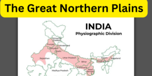
- They stretch from Rajasthan in the west to the Brahmaputra valley in the east, covering about 3200 km from west to east.
- Formed due to the subsidence of the northern part of the Indian Peninsula, which created a large basin.
- Filled with sediments from rivers originating from the north and south, forming the alluvial deposits of the plains.
- Formed by the Indus, Ganga, and Brahmaputra river systems and their tributaries.
- Largest alluvial tract in the world, with an average width of 150-300 km, increasing from east to west.
- Average depth of alluvium varies, with the maximum depth exceeding 8000m in parts of Haryana.
- Extreme horizontality (200m-291m above sea level), broken at micro-level by river bluffs and levees.
- Divided into three major zones: Bhabar, Tarai, and alluvial plains, further categorized into Khaddar and Bhangar regions.
- Flat nature of the land leads to frequent changes in river courses, particularly during floods.
- Kosi River, known as “The Sorrow of Bihar,” and Gandak River contribute to high flood risk in the area.
- Kosi River has shifted its course by more than 120 kilometers in the past 250 years due to heavy silt deposition during monsoon.
- Fertile features make the plains ideal for farming, cultivation, and crop production.
- The region supports a significant portion of India’s agricultural activities, contributing significantly to the country’s food security.
- Bhabar Plains
- Tarai Tract
- Bhangar Plains
- Khadar Plains
- Delta Plains
1. Bhabar Plains:The Great Northern Plains
- The Bhabar Plain is a narrow belt running parallel to the Shivalik foothills, about 8-10 kilometers
- It is wider in the western plains compared to the eastern plains of Assam.
- Rivers originating from the mountains deposit heavy rocks and boulders in this region, causing them to disappear due to high porosity.
- Coarse sediments carried by rivers form cone-shaped deposits called alluvial fans at the foothills of the Shivalik range.
- The Bhabar tract is unsuitable for crop cultivation and is mainly inhabited by the Gujjar community, known for cattle rearing.
- The name “Bhabar” comes from a tall grass called Eulaliopsis binata, used for making paper and ropes.
- It extends from Jammu to Assam, south of the Shivalik range, and is about 8-10 km wide.
- Rivers descending from the Himalayas deposit their load along the foothills, forming alluvial fans.
- The porosity of the pebble-studded rock beds is high, causing streams to sink and flow underground, resulting in dry river courses except in the rainy season.
- The Bhabar tract is not suitable for crop cultivation, and only big trees with large roots thrive there.
- The Bhabar belt is narrower in the east and wider in the western and north-western hilly regions.
2. Tarai Tract :
- Tarai is an Urdu word referring to lands at the foot of a watershed, characterized by low ground flooded with water, marshes, swamps, and meadows.
- Tarai Plains is a 10-20 km wide marshy region south of the Bhabar plains.
- In Tarai plains, streams and rivers re-emerge without defined channels, creating marshy and swampy conditions.
- Tarai plains have high rainfall, excessive humidity, thick forest cover, and rich flora and fauna.
- Suitable for cultivating crops like wheat, rice, maize, sugarcane, etc.
- The re-emergence of underground streams of the Bhabar belt transforms large areas into badly drained marshy lands.
- Much of the Tarai land, especially in Punjab, Uttar Pradesh, and Uttarakhand, has been reclaimed for agriculture.
- The region is infested with mosquitoes and susceptible to diseases like Japanese Encephalitis (JE).
3. Bhangar Plains:
- It is the older alluvium along the river beds forming terraces higher than the flood plain.
- Dark in colour, rich in humus content and productive.
- The soil is clayey in composition and has lime modules (called kankar)
- Found in doabs (inter-fluve areas)
- ‘The Barind plains’ in the deltaic region of Bengal and the ‘bhur formations’ in the middle Ganga and Yamuna doab are regional variations of Bhangar. [Bhur denotes an elevated piece of land situated along the banks of the Ganga river especially in the upper Ganga-Yamuna Doab.
- This has been formed due to accumulation of wind-blown sands during the hot dry months of the year]
- In relatively drier areas, the Bhangar also exhibits small tracts of saline and alkaline efflorescence known as ‘Reh’, ‘Kallar’ or ‘Bhur’. Reh areas have spread in recent times with an increase in irrigation (capillary action brings salts to the surface).
- May have fossil remains of even those plants and animals which have become extinct.
4. Khadar Plains :
- The Khadar Plains consist of new alluvial deposits along the river courses.
- These lands are wider in the eastern regions of India due to the larger flood areas created by Himalayan rivers.
- The Khadar tracts receive fresh deposits of silt every year during the rainy season. They are composed of sand, silt, clay, and mud.
- Much of the Khadar land has been brought under cultivation, primarily for crops like sugarcane, rice, wheat, maize, and oilseeds.
- These alluvial plains, including both Khadar and Bhangar, stretch approximately 100 kilometers from north to south and feature mature fluvial erosional and depositional landforms such as sandbars, meanders, oxbow lakes, and braided channels.
- The Brahmaputra plains are particularly known for their riverine islands and sandbars. Additionally, the region witnessed the first Green Revolution in India during the 1960s-70s.
5. Delta Plains :
- Delta plains arise around the mouths of great rivers, such as the Ganga, resulting in enormous deltas like the Sunderbans.
- These plains have a relatively flat elevation, spanning between 50 and 150 meters above sea level.
- These plains, which cover 190,000 square kilometers, are depositional zones caused by the river’s slow flow.
- The deltaic plain is made up of three types of mud: old, new, and marsh.
- Uplands in the delta plains are called “Chars,” whereas marshy areas are called “Bils.”
- The region is ideal for farming jute, tea, and rice.
- The Sundarban delta, which is at the confluence of the Ganga and Brahmaputra rivers, is the largest and fastest-growing delta.
The Great Plains Of India: Geographical Location
On the basis of deposition of sediments by various rivers and topographical characteristics, the Northern Plains of India is divided into the following four major regions:
- Plains of Rajasthan
- Punjab Haryana Plains or North Central Plains
- Ganga Plains
- Brahmaputra Plains
1.Plains of Rajasthan:The Great Northern Plains
- Plains of Rajasthan cover approximately 175,000 square kilometers, located west of the Aravalli Range.
- Formation of these plains includes recession of the sea, evident from saltwater lakes like Sambhar Lake.
- During the Permo-carboniferous period, most of the Rajasthan plain was submerged under the sea.
- The region is now mostly desert terrain with sand dunes and barchans.
- The Indira Gandhi Canal has facilitated intensive agriculture in the northwestern region.
- Brackish lakes like Sambhar Lake exist due to marine submergence that subsided during the uplift of the Himalayan phase.
- Dry river beds of Saraswati and Drishadvati indicate the area’s earlier fertility; Luni is the only flowing river now.
- The Rajasthan Plains are desert areas covered with sand dunes and barchans.
- These plains are separated from the Bagar region by the 25cm Isohyet.
2. Punjab Haryana Plains or North Central Plains :
- The Punjab-Haryana plain stretches over an area of approximately 650 kilometers from northeast to southwest and 300 kilometers from west to east.
- It is an aggradational plain formed by the Satluj, Ravi, and Beas rivers. The Delhi Ridge acts as a divider between these plains and the Gangetic plain.
- The height of the plains gradually decreases from around 300 meters in the north to 200 meters in the southeast.
- The general slope of the plains is from northeast to southwest and south. The plains located between two rivers are called doabs, such as the Bist doab between the Beas and Sutlej rivers.
3. Ganga Plains:The Great Northern Plains
- The Ganga plains encompass the area between the Yamuna catchment in the west and the Bangladesh border in the east.
- Spanning approximately 1400 kilometers in length and with an average width of 300 kilometers, this region has a gentle gradient of about 15 centimeters per kilometer.
- Ganga Plains can be further subdivided into the following sub-regions:
The Upper Ganga Plain:
- It covers portions of the Agra Division, the Rohilkhand Division, and the Ganga-Yamuna Doab.
- It is one of India’s most productive and fertile plains, and the Green Revolution has had great success here.
- The presence of Bhur (undulating, aeolian sand deposits) is a distinctive characteristic of the Upper Ganga Plain.
The Middle Ganga Plain:
- It covers portions of the central and eastern Uttar Pradesh and the Bihar Plains up to Muzaffarpur and Patna.
- Rivers like Kosi frequently shift their courses in this area due to the low gradient of the plain.
The Lower Ganga Plain:
- Extending from Patna to the Bay of Bengal, this sub-region is bordered by Assam and Bangladesh in the east, the Chotanagpur plateau in the west, and the Sundarban delta in the south.
- The rivers Tista, Sankosh, Mahananda, Damodar, and Subarnarekha also drain this area.
- The lower Ganga plain is marked by sediment-filled faults resulting from the movement of the Indian plate. In the delta region, the Ganga splits into several distributaries, with the Hooghly being a prominent example.
4. Brahmaputra Plains:The Great Northern Plains
- This plain forms the eastern part of the northern plain and lies in Assam.
- Its western boundary is formed by the Indo-Bangladesh border as well as the boundary of the lower Ganga Plain. Its eastern boundary is formed by Purvanchal hills.
- The region is surrounded by high mountains on all sides, except on the west.
- The whole length of the plain is traversed by the Brahmaputra.
- The Brahmaputra plains are known for their riverine islands (due to the low gradient of the region) and sand bars.
- The innumerable tributaries of the Brahmaputra river coming from the north form a number of alluvial fans. Consequently, the tributaries branch out in many channels giving birth to river meandering leading to the formation of bill and ox-bow lakes.
- There are large marshy tracts in this area. The alluvial fans formed by the coarse alluvial debris have led to the formation of terai or semi-terai conditions.