
The Himalayan(Northern) Mountains
- The Himalayan(Northern) Mountains,The Himalayas are the tallest and most rugged mountain range on Earth, with greater altitudinal variations in the eastern half compared to the western half.
- The southern slopes of the Himalayas are steeper than their northern counterparts, separated by the Himalayan Front Fault (HFF).
- The Himalayas act as a physical, climatic, drainage, and cultural divide, serving as a barrier between the plains and the mountains.
- The general alignment of the mountain ranges in India is northwest to southeast, except in regions like Darjeeling and Sikkim (east-west) and Arunachal Pradesh (southwest to northwest).
The Himalayas span approximately 2,400 kilometers and form an arc with a width ranging from 400 kilometers in Kashmir to 150 kilometers in Arunachal Pradesh.
- Longitudinal divisions of the Himalayas include the Trans-Himalayas, Greater Himalayas, Lesser Himalayas, and Shiwaliks.
- The Trans-Himalayas consist of Tethys sediments underlain by ‘Tertiary granite’, including the Karakoram, Ladakh, and Zaskar Mountain ranges in India.
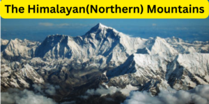
- The Greater Himalayas rise abruptly with an average elevation above 6,100 meters, hosting peaks like Mount Everest, Kanchenjunga, and Nanga Parbat.
- The Lesser Himalayas span around 80 kilometers in width with an average elevation ranging from 1,300 to 4,600 meters.
- The Shiwaliks extend 10-50 kilometers in width with an elevation ranging from 900 to 1,100 meters, composed of unconsolidated sediments brought by rivers from the main Himalayan ranges.
- The Himalayas have been divided on the basis of regions from west to east, generally demarcated by river valleys.
- The Himalayas are formed by the convergence of the Indo-Australian Tectonic Plate with the Eurasian (Asian) Tectonic Plate.
- The series of events leading to the formation of the Himalayas include the breaking of the supercontinent Pangea, formation of the Tethys Sea, deposition of sediments, convergence of plates, formation of folds, and eventually the genesis of the Himalayas.
- The convergence of the Indo-Australian and Eurasian Plates continues, leading to the rising of the Himalayas by about 5 mm per year.
- The Trans-Himalayas
- The Himalayas
- Purvanchal Hills
1.The Trans-Himalayas:The Himalayan(Northern) Mountains
- Located north of the Great Himalayan Range, in Jammu and Kashmir and the Tibetan Plateau.
- Also known as the Tibetan Himalayas due to their extent in Tibet.
- Extends about 1,000 km in an east-west direction.
- Average elevation is approximately 3,000 meters above sea level.
- Width varies from 40 km at the extremes to about 225 km in the center.
- Contains Tethys sediments and fossils of marine sediments.
- Rocks include ‘Tertiary granite’ and partly metamorphosed sediments.
- Forms the core of the Himalayan axis.
Karakoram Range:
- Northernmost range of Trans-Himalayas in India.
- Forms boundary with Afghanistan and China.
- Home to some of the highest peaks and largest glaciers.
- Includes K2, the second-highest peak in the world.
Ladakh Range:
- Southeastern extension of Karakoram Range.
- Extends from mouth of Shyok River to Indo-Tibetan borders.
- Deosai Mountains and Kailash Range considered part of Ladakh Range.
Zaskar Range:
- Runs parallel to Great Himalayan Range.
- Extends southeast from Suru River to upper Karnali River.
- Includes Kamet Peak, the highest peak at 25,446 feet.
Significance of Trans-Himalayas:
- Composed of granitic and volcanic rocks, formed between 110 and 40 million years ago.
- Resulted from collision of Himalayan plate with Eurasian plate.
- Includes northernmost states of Jammu & Kashmir, Uttarakhand, and Himachal Pradesh.
- Extension of Tibetan plateau around Himalayas, lacking clear alignment or extensive river gorges.
2.The Himalayas:The Himalayan(Northern) Mountains
- The Himalayas are the world’s highest and longest young fold mountains, produced by the collision of Indian and Eurasian plates.
- India is advancing north, and the height of the Himalayas is still expanding at a rate of 5 cm every year.
- The Himalayas, also known as Himadri and Himavan, are primarily made up of uplifted sedimentary and metamorphic rocks.
- The northwest is bounded by the Karakoram and Hindu Kush ranges, the north by the Tibetan Plateau, and the south by the Indo-Gangetic Plains.
- The Himalayas stretch over 2,400 kilometers from the Indus Gorge in the west to the Brahmaputra Gorge in the east, with the western range being broader.
- The average elevation is approximately 6,100 meters, with a moderate height shift in the west and a quick change in the east.
- The Himalayas are divided into three parallel ranges:
Himadri or Greater Himalayas
Himachal or the Lesser Himalayas
The Outer Himalayas or Shivalik
- The mountains’ orientation varies by area, from northwest-southeast to east-west.
- Forest cover diminishes westward, mirroring the pattern of rainfall reduction from east to west.
1.Himadri or Greater Himalayas:
- The Greater Himalayas are also known as the Himadri, Inner Himalayas, or Central Himalayas.
- Composed of Archaean rocks like granite, gneisses, and ancient schist.
- Orientation changes across regions: southeast in Pakistan, India, Nepal; eastwards in Sikkim, Bhutan; northeast in Arunachal Pradesh.
- Contains world’s highest peaks like Nanga Parbat, Mount Everest, Kanchenjunga, Namcha Barwa.
- Northern slopes are steep, southern slopes are gentle.
- Covers 2400 km from west to east, with width of 120-190 km.
- Average height of mountains is 6000 m.
- Most continuous range with prominent peaks, core made of granite.
- Contains Mount Everest (8850 m), Dhaulagiri (8172 m), Makalu (8481 m), Kanchenjunga (8586 m).
- Other prominent ranges: Annapurna, Nanga Parbat, Kamet.
- Rivers like Yamuna and Ganga originate from this range.
2.Himachal or the Lesser Himalayas:
- The Himalaya Mountain Range’s middle segment is known as Himachal, or the Middle Himalayas.
- It stretches around 2,400 kilometers from northeast to southeast along the northern border of the Indian subcontinent.
- The average width is 50 kilometers, and the average height is 3700–5000 meters.
- Major ranges include Mahabharat, Dhauladhar, Pirpangal, and Nag Tibba.
- Kangra, Kashmir, and Kulu are among the most well-known valleys in this region.
- Major rivers such as the Jhelum and Chenab travel through this range.
- The Valley of Kashmir is located between the Pir Panjal and Zanskar ranges.
- Nainital, Darjeeling, Ranikhet, and Shimla are among the most well-known hill stations.
- The Middle Himalayas are often referred to as Lesser Himalayas or Lower Himalayas.
- Karewas are fluvioglacial deposits that develop between the Greater and Middle Himalayas (Pir Panjal).
- The main rocks in this range include slate, limestone, and quartzite.
3.The Outer Himalayas or Shivalik:
- The Shivalik Ranges are the Himalayas’ southernmost hills, separated from the Lesser Himalayas by flat-bottom valleys.
- They extend approximately 2400 kilometers from the Indus gorge to the Brahmaputra, with heights rarely exceeding 1300 meters and widths ranging from 10 to 50 kilometers.
- The southern hills of Himachal Pradesh and Punjab lack forest cover and are divided by seasonal torrents known as Chaos.
- Longitudinal valleys between Himachal and Shivaliks, called as Duns, are important features, including Patli Dun, Kotli Dun, and Dehradun.
- The rise abruptly from the Indus and Ganges river plains in the south, paralleling the main Himalayan range in the north and separated by valleys.
- The Churia Range refers to a section of Nepal’s Shivalik Mountains.
- The Shivaliks’ upliftment hindered river flows, resulting in ephemeral lakes.
- When rivers cut through, they leave fertile alluvial soils known as Doons in the west and Duars in the east, which are essential for tea growth.
- The Shivaliks accumulated conglomerates, which blocked river routes and formed ephemeral lakes. The lakes gradually drained, producing plains known as Doons or Duns in the west and Duars in the east.
3.Purvanchal Hills:The Himalayan(Northern) Mountains
- The Eastern Hills, also known as Purvanchal, are a series of relatively low hills in the eastern part of India.
- They extend from Arunachal Pradesh in the north to Mizoram in the south, forming India’s border with Myanmar.
- Prominent ranges in Purvanchal include Patkai Bum, Naga Hills, Manipur Hills, and Mizo Hills (or Lushai Hills).
- The Barail Range splits the Naga Hills from the Manipur Hills.
- These ranges are known by various local names in different regions.
- Physiographic features include Loktak Lake in Manipur and soft, unconsolidated deposits in Mizoram.
- Tributaries of the Brahmaputra flow through most of these regions.
- Diverse tribal groups inhabit these areas, practicing Jhum cultivation.
Subdivision of Himalayas:The Himalayan(Northern) Mountains
- Kashmir or North-western Himalayas
- Uttaranchal Himalayas and Himachal
- Sikkim Himalayas and Darjeeling
- Arunachal Himalayas
1.Kashmir or North-western Himalayas:
- Spanning approximately 350,000 square kilometers, the Kashmir Himalayas stretch about 700 kilometers in length and 500 kilometers in width.
- This region is situated between the Indus and Ravi rivers.
- With an average elevation of 3,000 meters, it boasts India’s highest concentration of glaciers, including notable ones like Baltoro and Siachen glaciers.
- The Kashmir Himalayas comprise several ranges, including the Karakoram, Ladakh, Zaskar, and Pir Panjal.
- The northeastern part, known as Ladakh, is a cold desert nestled between the Greater Himalayas and the Karakoram It is one of the highest inhabited regions globally.
- The picturesque Kashmir Valley and the famous Dal Lake lie between the Great Himalayas and the Pir Panjal range.
- The Kashmir Valley features Karewas formations, thick deposits of glacial clay and other materials mixed with moraines, highly suitable for saffron cultivation.
- The southernmost part comprises longitudinal valleys known as ‘duns,’ including Jammu duns and Pathankot duns.
- Noteworthy mountain passes include Zoji La in the Great Himalayas, Banihal in the Pir Panjal range, Photu La in the Zaskar range, and Khardung La in the Ladakh
Uttaranchal Himalayas and Himachal:
- The Himachal and Uttarakhand Himalayas cover approximately 83,000 square kilometers, spanning Himachal Pradesh. This region features the Greater Himalayas, Lesser Himalayas (Dhaoladhar in Himachal Pradesh and Nitibha in Uttarakhand), and Shivalik Himalayas.
- It lies between the Ravi and Kali rivers, drained by the Indus and Ganga river
- Tributaries like the Ravi, Beas, Sutlej, Yamuna, and Ghaghara flow through this area. The northern part connects to the Ladakh cold desert.
- Uttarakhand boasts glaciers like Gangotri, Milam, and Pindar. Its northern slopes are lush with forests, plains, and lakes, while the southern slopes are rugged and forested.
- The Valley of Flowers lies here. The region features the ‘Shiwalik’ and ‘Dun formations’ like the Chandigarh-Kalka dun and Nalagarh dun, with Dehra Dun being the largest.
- The Bhotias inhabit the valleys in the Great Himalayan range, migrating to ‘Bugyals’ in summer and returning to the valleys in winter.
- Sacred sites like Gangotri, Yamunotri, Kedarnath, Badrinath, and Hemkund Sahib are found here.
- The region is known for five Prayags (confluences) – Vishnu Prayag, Nand Prayag, Karn Prayag, RudraPrayag, and DevPrayag.
- Altitudes between 1,000 and 2,000 meters attracted British colonial development, leading to hill stations like Dharamshala, Mussoorie, Shimla, and cantonment towns like Kasauli.
Sikkim Himalayas and Darjeeling:
- The Darjeeling and Sikkim Himalayas, situated between the Nepal and Bhutan Himalayas, are a significant part of the Himalayan range.
- Unlike other sections, they lack Shivalik formations but feature “duar formations,” utilized for tea cultivation.
- The region is known for rivers like the Teesta, towering peaks, and deep valleys.
- Kanchenjunga (8,598 meters), the world’s third-highest peak, lies on the India-Nepal border. Passes like Nathu-La and Jelep-La connect Gangtok with Lhasa, Tibet.
- The area’s higher reaches are inhabited by the Lepcha tribes, while the Darjeeling Himalayas have a diverse population including Nepalis, Bengalis, and tribes from Central India.
- Favorable conditions like moderate slopes, rich soil, well-distributed rainfall, and mild winters led the British to introduce tea plantations.
- These regions are celebrated for their scenic beauty, rich flora and fauna, and diverse orchids.
Arunachal Himalayas:The Himalayan(Northern) Mountains
- Extending from the eastern portion of the Bhutan Himalayas to the Diphu Pass in the east, the Arunachal Himalayas follow a general southwest to northeast direction.
- This region experiences a rapid elevation increase from the plains of Assam. Notable mountain peaks in the area include Kangtu and Namcha Barwa.
- The ranges are deeply dissected by swiftly flowing rivers that run from north to south, forming impressive gorges.
- The Brahmaputra River, after passing Namcha Barwa, flows through a deep gorge. Among the significant rivers in the region are the Kameng, Subansiri, Dihang, Dibang, and Lohit, all of which have perennial flow and possess a high hydroelectric power potential.
- Due to the region’s abundant rainfall, fluvial erosion is highly pronounced. Several important passes in this area include Bomdi La, Diphu, and Pangsau La.
- Notable tribes from west to east include the Monpa, Daffla, Abor, Mishmi, Nishi, and Nagas. Most of these communities engage in Jhumming, a form of shifting cultivation.
- As a result, interactions between communities are primarily conducted through the duar region along the Arunachal-Assam border
The Himalayan(Northern) Mountains